EPISODE: 28
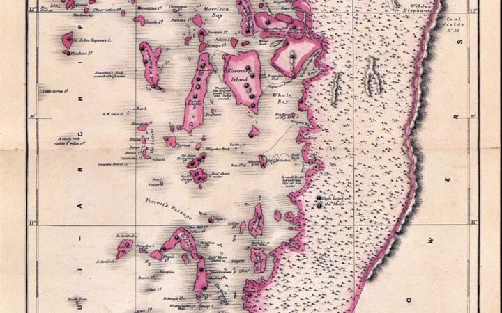
Mr J J A Page returned to headquarters from Burma on 7 June 1908 and was subsequently reposted to South Burma to continue his investigations of the tin deposits. He departed headquarters on 16 October 1908. Mr Page’s findings on the geology and tin deposits of the Mergui Archipelago and Tavoy district were documented in Volume XXXVIII, Part 1 of the Records of Geological Survey of India in 1908. I am delighted to provide a concise account of the granite islands in the Mergui Archipelago and Tavoy district, where I conducted tin and tungsten exploration both on land and offshore areas between 1974 and 1987 as part of the UN-aided Tenasserim Tin/Tungsten Project and Offshore Tin Exploration Project.
Mr Page continued his survey of the Mergui district, devoting the first quarter of the year to an examination of the archipelago. In these islands, granite forms the prevailing rock feature, and it occurs both in the gneissoid form, apparently similar to the usual Archaean gneiss, and in a distinctly intrusive form, the latter penetrating both the older granitoid gneisses and the sedimentaries.
The islands in which granite was observed may be divided into six groups: –
(1) The western group consisted of Moscos, Metcalfe, Great Western, Torres, Hayes, Fletcher and Clara. All the intermediate parts of this outer group are also probably granitic. Both kinds of granite were observed in this group.
(2) An ill-defined group comprises the western part of Elphinstone, southeast Elphinstone, Grant, the northern half of Ross, Maingay’s, and smaller islands as far east as Cantor. The larger portion is of gneissose granite, into which the younger granites and numerous quartz porphyry dykes have penetrated.
(3) A large domed outcrop, a little south of King’s Island Sound, all the south of King’s, Mergui, Sellore, Tucker, Julian, and the central ranges of Kissering. In this group, gneissose granites predominate.
(4) Parker and Domel, down to and including High Island, form another series of basal granites; they may be traced north through the Pickwick group into Cantor, south through the Gregories, and down the coast to Victoria Point and the adjacent islands.
(5) Davies Island is apparently an isolated granite outcrop, but extremely bad weather prevented the adjacent islands from being carefully examined, and there may be granites in the interior of St. Matthew’s.
(6) Koolagyun and the low islands, mostly covered by swamps which extend for miles down the coast, are composed of granite, usually of the basal variety, with intrusive granites and pegmatite veins penetrating them in all directions.
Quartz-porphyries form a very important factor in group 2. They occur intrusive into granites and the sedimentaries. Mount Elphinstone (west coast Elphinstone Islands), the peak on Maingay’s, and Cantor are all examples of intrusion into granites; and Hayes, Julia, the extreme south of Cantor, and some islands east of Ross show examples of intrusions into slates. Jhonny, Paton, Allan and other islands nearby are composed for the most part, if not entirely, of quartz-porphyries.
Mergui Series
Above the granitic rocks is a series of indurated sandstones, quartzites, slates and schists. As a rule, these rocks are much crushed, at times sparsely mineralised, and generally do not cover any considerable area. They are usually met within small mountain streams. Above these comes a series of slates, sandstones, grits and conglomerates. But they are not always all present, denudation having generally removed the last-mentioned rocks. As far as is known, Pataw is the only island formed of conglomerate.
The series may be observed in the following groups of islands: Central Kings, some 7 miles from the east coastline. Iron, the north-east of Maingay’s island and the adjacent islands, central and north-east Elphinstone, Macleod’s, Southern Ross and adjacent islands, the Warden, Christmas, Bentinck, the Five Sisters, St Luke’s, St Matthew’s in parts, Bushby, Father and Son, Lord Loughborough, and Governor Swinton and Cavern are all of sandstone and belong to the lower part of the Mergui series. Hayes, Julia, Cantor (south end) and Sullivan are all slate islands and may be classed with the above.
Moulmein Group
No rocks that could be safely attributed to this group were discovered. The limestones forming the Elephant group and those on the southeast of St Matthew’s Islands are probably older than the adjacent slates and conglomerates. They are very crystalline and apparently fossiliferous.
Recent Deposits
Three younger deposits remain, which cannot be classed as one, and yet are probably of about the same age. Between them, they cover quite a considerable area of the low flat islands, mentioned in group 6 of the granites, and also some of the islands on the south, the swamps and parts of the mainland. They are laterite, a partly cemented boulder-breccia and lithomarge.
They are all shallow, the laterite being seldom thicker than 14 feet, the conglomerates even less, and the lithomarge seldom over 60 feet. They all appear near granite and overlie them and the older Mergui series’ adjacent slates, schists, etc.
The laterites and the conglomerates are often found associated with the laterites and the lithomarges in the more southern parts of the archipelago. The laterites on Koolagyun and some adjacent islands are rich in iron, which can be used as an ore.
The conglomerates in the vicinity of Yengan-Bokpyin often cover workable tin-bearing gravels and some of the felspar of the granites; the mottled appearance (red to blue) being due to the oxidation of iron derived from the dark mica, the tourmaline and the magmatic of the granites. The islands of Pumpkin, Pig, the Gregories, Carnac, Collins, Jenkins, etc, all furnish examples of these three younger deposits.
Cassiterite
Cassiterite is found in gravels on King’s, Kissering and Davies Islands. On the first name, it has worked. Kissering is the best of the three and is worth prospecting, the cassiterite occurring within six feet of the surface. The tin on Davies Island, to be judged by the places tested in the stream that enters the sea near the southeast corner of the island, would not pay to work. All the granite of sub-group 2 is worth prospecting for cassiterite. Although quartz lodes were frequently found, none carried visible minerals of economic value.
Gold
Gold is found on Horsborough Island and has been worked. It occurs as small flakes in gravel at comparatively shallow depths. On Russel Island, a series of pyrite veins a little above sea level yield ten dwts gold or assay. Several quartz stringers cross these veins.
Tavoy district
At the end of March 1908, Mr Page proceeded to the Tavoy district. In this district, tin mining was found to be at a standstill. The following localities in which stream washing is carried on during the monsoons were visited: –
(a) Maungmeshaung river.
(b) Ongbingwin.
(c) The Hindu River and its tributary streams, including the Hinda river.
(d) There are old workings in the vicinity of the granites near Wagon and about the village of Pagaye.
The investigation results hold out no great hopes for the future of the tin industry in this district. The following is a more detailed description of these localities.
(a) Maungmeshaung: The cassiterite is derived from the granites as well as from quartz veins at the slate-granite junction. Boulders of each of these rocks carrying cassiterite are to be found in the stream. Apparently, two concentrations have taken place, one in which the cassiterite was concentrated on a thin clay layer on the denuded slates, where the present stream washed them. The gravels are irregular, and the concentrated cassiterite will only pay to wash at intervals. European prospectors will find it more profitable to search for lodes in this locality than to work the gravels. Wolfram is associated with cassiterite and occurs in rather large irregular segregations and thin veins in larger quartz veins in the slates.
(b) Ongbingwin: The cassiterite occurs in quartz veins; the widest cassiterite-bearing vein found was only 12 inches thick. Cassiterite also occurs in small quartz stringers, which have penetrated the sandstones near the granites in directions that cause the sandstones to split in irregular rhomboidal masses. Probably, most of the cassiterite found in the gravels about the base of Kehdaung is derived from this source. For a long time to come, cassiterite will be concentrated in the streams during the monsoon in quantities that will pay to work. It is extremely doubtful whether it would pay a company to attack the hill on a large scale. The natives are only able to work the gravels down to about 6 feet, and from one or two who worked with European prospectors provided with pumps, it was ascertained that the concentrate proper is some 30 feet below the present surface.
(c) The Hindu River and its tributaries drain a portion of the central range east of Wagon. The Hindu enters the Khamaungthway, the Hinda, and the Bean River, each tributary of the Great Tenasserim. Cassiterite, in quantities that should be payable, exists within a few feet of the surface, and in the valley of the Hindu, gold is found with the tin concentrate. Evidence obtained from boulders shows a strong probability of a quartz lode existing between the Hinda and Hindu. The boulders discovered carry tin payable proportion and indicate that the lode is at least 30 inches wide. This lode will cross streams which are already leased for lampan workings.
(d) At the base of the granite hills near Wagon and north of the road, there are old workings, and in isolated patches, cassiterite, sufficiently concentrated to be worth washing on a small scale, may be found. This locality is approximately south-south-east of the tin workings on the Maungmeshaung stream. There is a possibility of lodes being found, but pits will be necessary. At Pagaye’, there are tin-bearing gravels, which are, however, worked out. The quartz veins occur in slate of the Mergui series, which is partly metamorphosed to schist. This locality gives promise of future success to the prospector.
Besides visiting the above localities, a tour was made from the Tavoy River, in a general south-easterly direction to near Mount Myinmolet-kat and down the Bean River to Myitta. The structure of this region is much the same as that of the archipelago. Numerous gravel areas looked like they might contain cassiterite, but testing them in stream cuttings even down to 14 feet proved unsuccessful.
In November, a tour was made across the country from the Tavoy to the coast and along the granite hills to the Heinze Basin. All the highland is granite, and the disintegrated granite sands cover large flats. Floods prevented panning in the streams, but from the general appearance of the country, there should be gravels worth working on, as well as lode formations near the granites worth testing.
References: Page J J A, 1908: General Report for1908, Record of Geological Survey of India, Vol. XXXVIII, Part 1.
