By THAN HTUN (GEOSCIENCE MYANMAR)
EPISODE:34
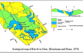
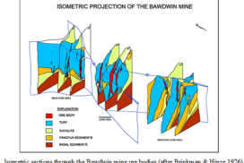
Geology and Ore Deposits of the Bawdwin Mines
The GSI geologist J Coggin Brown reported geology and ore deposits of Bawdwin Mines in 1917, and the concise account of his report is as follows:-
Introduction
The Bawdwin Mines of the Burma Corporation Limited lie in Longitude 97 18’, Latitude 23 6’, approximately in the Tawnpeng (Taungbaing) State, one of the smaller Northern Shan States. They are connected with the Mandalay-Lashio section of the Burma Railways by a narrow-gauge (two-foot) line, 50 miles long, that meets the Burma Railways at Namyao, 517 ½ miles from Rangoon and 167 ½ miles from Mandalay. The narrow-gauge railway, which winds about in the usual manner of mountain lines, crosses the Namtu River at Namtu, the site of the head offices, smelters, and residential quarters of the company, and then ascends through the gorge of the Nam Pangyun stream to Bawdwin, gaining elevation as it does so use a spiral loop and double reverse.
According to Maclaren, the average height of the mine area above sea level is 3,200 feet. The collar of the vertical shaft is about 3,240 feet. The lowest part of the concession below the mouth of the E R Valley is 2,790 feet, while the highest (Mount Herschell) is 4,615 feet. The bed of the Nam Pangyun drops 1,000 feet while passing through the lease. The average depth of the bed of the river beneath the crests of the ridges on either side is 1,000 feet. The concession area is 2,496 acres, and all the known old workings and slag heaps are within it.
Previous work and acknowledgements
Geological fieldwork was commenced near Bawdwin by Dr J Malcolm Maclaren, then Mining Specialist to the Government of India, in 1906. A preliminary report on the results of a fortnight’s visit to the mines in February 1907 has been published by T H D La Touche and myself (Rec, GSI, Vol XXXVII). At that time, it was found impossible to survey the area accurately until the completion of the 1 inch = 1 mile map of the Survey of India. This was available in 1909-10, and the present investigation was undertaken in 1914-15 when I was again deputed to Bawdwin by the Government of India. The months of November, December, and January were occupied by a study of the silver-lead-zinc ores discovered in situ since my earlier visit and by the mapping of the rhyolites and associated tuffs. In February, March, and April, I made extension tours through the surrounding districts.
The Bawdwin mines, although operated for centuries by the Chinese, are still in the early stages of development, and hardly a day has passed without the revelation of some fact requiring a modification of a previously formed theory. With these reservations, it may be stated that this report is intended to describe the broad outlines of the geology of the district and to summarize the available evidence regarding the origin and distribution of the ores.
I owe a great deal to the courteous cooperation of Burma Corporation Limited, which has invariably given free access to maps and plans and furnished any information asked for. Amongst those to whom I am particularly indebted are Mr C H Macnutt, Resident Manager, Mr T E Mitchell, Mines Manager, and Mr M H Loveman, Geologist of the Company. The friendly help of these gentlemen given ungrudging in the office, the field, and the mine is gratefully acknowledged.
Only the geologist who has worked in unexplored parts of the Shan States is in a position to appreciate adequately the pioneer work of T H D La Touche. It is certainly a result of his labours that new districts can be surveyed at any reasonable time at all. I have made free use of Dr J M Maclaren’s results as set forth in his earlier manuscript report to the Government of India and his later one written as a result of a recent visit on behalf of the company. To both of these gentlemen, my thanks are acknowledged here.
History of the Mines
The Bawdwin Mines, known to the Burmese as “Bawdwingyi” or “Great Silver Mines” and to the Chinese as “Lao-Yin-Chang” or “Old Silver Mines”, have been worked for s ilver for hundreds of years, though they did not attract the attention of Europeans before 1795.
The date of commencement of the Chinese operations at Bawdwin is lost in antiquity. It has been stated that this date was probably more than 1,000 years ago, but there seems to be no authority to consider it as early as this. Maclaren is of the opinion that Bawdwin was made Chinese during the invasion of 1343 AD and placed considerable reliance on an inscription that came into his hands and was said to have been found at Bawdwin. According to Mr Taw Sein Ko, the Government Archaeologist in Burma, this record states that work was commenced at Bawdwin by the Chinese in the 9th year of Emperor Ching-tsou (Yonglo) of the Ming dynasty. This date in Western reckoning is 1412 AD.
Recent Chinese records show that the mines were worked during the reigns of Chia Ching (1796-1821) and Tao Kuang (1821-1851). In the accounts of the early missions to the Burmese court at Ava, from Michael Symes in 1795 to that of Sir A Phayre, who was accompanied by Dr T Oldham, Superintendent of the Geological Survey of India, in 1855, references can be found to the mines. Still, no European was allowed t o visit them, and in 1895, when the 6th edition of the quarter-inch topogr aphical map was compiled, so little was known of them that their position was not marked. Symes, in 1795, called the place Badouem and said it was a six-day journey from Bamoo (Bhamo). Crawford, in 1827, had the advantage of seeing two Chinese traders from Bawdwin and estimated the value of the annual production to be 960,000 ticals, while the royalty payable to the King of Ava was 4,800 ticals per annum. He places the locality, which he calls Bor-twang, at a 12-day journey from Bhamo and states that the number of men employed was about 1,000 (Crawford: Journal of an Embassy to the Court of Ava).
At the time of my first visit to Bawdwin, there were abundant traces of the Chinese occupation quite apart from the furnaces and enormous slag dumps. A typical Chinese stone-paved road ran up the valley, crossing the stream by three arched stone bridges in perfect preservation. In one prominent position now occupied by the geologist’s bungalow, the remains of a large stone temple were approached by a broad flight of stone steps and guarded by two carved stone lions. The extensive deforestation of the surrounding country is also essentially Chinese. The bare appearance of the immediate neighbourhood and the country to the north and northeast is most striking in a land clothed for the most part in the primaeval forest. It is due to several causes: the destruction of the timber for the fuel supply of the smelters, the action of the acid fumes in the south-west monsoon, and, finally, to the general Chinese strategy, which invariably strips a country of all its big vegetation.
The Chinese finally abandoned Bawdwin in about 1868 as a direct result of the great Mahomedan rebellion in Yunnan. It is said that after the final departure of the Chinese, the Burmese kings Mindon and Theebaw sent “armies” to work the mines, but epidemic diseases and the ravages of a bad climate killed the colonists. It is very doubtful if the Burmese ever possessed sufficient mining or metallurgical skill to make a success of an ore deposit like that of Bawdwin.
From that time until modern history begins, the huge slag heaps and the mines have lain undisturbed, except for the occasional visits paid by bands of Kachins who carried off the richer lead matte and smelted it in small furnaces with charcoal on the hills around, using the lead so produced for bullets. Tiny heaps of these re-treated slags are common in the country around the mines. According to Maclaren, the mines were first brought to the notice of the authorities as the source from whence the Kachins drew their supply of lead.
From the records preserved in the archives of the Superintendent of the Northern Shan States at Lashio, I gather that Messrs. Sarkies Brothers of Rangoon were the first to apply for a Prospecting License over the area on 8 January 1902. In March of the same year, the Taungpeng Sawbwa, when stating that he had no objection to the license being granted, said that he knew the locality in question, that silver was found there and extracted many years ago in the time of his father. On 22 April 1902, the Lieutenant-Governor of Burma sanctioned the issue of a prospecting license for silver over an area of 16 square miles to Messrs. Sarkies Brothers, and on 26 May, the prospecting license indenture was signed. On 29 January 1903, the Lieutenant-Governor sanctioned the transfer of the prospecting license from Messrs. Sarkies to the Great Eastern Mining Company Limited, the chairman of which was Mr M F Kindersely. The prospecting license was extended for a period of one year in March 1903, and again in June 1904, with a yearly rent of Rs 48 being charged each year. But in the same year 1904, the Great Eastern Mining Company applied for a mining lease of 3.9 square miles at Bawdwin to extract silver, copper, lead, and zinc, which the Government of India granted. Up to June 1905, according to the Administration Report of the Northern Shan States for 1904-05, they took no further steps and withdrew all their employees from Bawdwin, so it seemed that the project had been abandoned or at least deferred. The same report for 1905-06 stated that it was understood that the Great Eastern Mining Company had been reconstituted and would shortly take steps to obtain the Bawdwin lease. In 1906-07, the new company known as the “Burma Mines Railway and Smelting Company Limited,” which had purchased the interests of the Great Eastern Mining Company, who were unable to carry on their projects due to lack of funds, obtained the Bawdwin lease for 30 years and made their progress in the construction of the light railway from Manpwe, on the Lashio branch o the Burma Railways, to the concession, a total length of slightly over 50 miles.
In 1907-08, the name of the company was again changed to the “Burma Mines Company Limited.” Disappointingly slow progress was being made with the railway, owing to labour difficulties and troubles from slips and wash-outs during the rains. Still, at the end of the period, 42 miles of rail were open, half of which was ballasted and half packed with earth. The bridge, which spans 134’ across Namtu, was about half finished. The transportation of the old Chinese lead slags by road for 2 ½ miles to a point where they could be shot onto the line was started. A tunnel was also commenced at Bawdwin to tap the mines below the level of the Chinese workings. The erection of the smelting plant to treat the slags at Mandalay Shore was completed.
In 1908-09, the bridge across the Namtu was completed; at the beginning of 1090, the railhead was at Tiger camp, and it was completed at the main slag heaps at Bawdwin by the first week of December 1909. Up to this date, mules and bullocks have brought slag from the mines to Tiger camp. The first slag was hauled over the line in December 1908, and from that time to the end of 1909, a total tonnage of 14,019 tonnes of slag and ore was delivered at Manpwe. The difficulties met with in railway construction are shown by the fact that between Tiger camp and Bawdwin – a difference in elevation of 500 feet in a distance of 2 miles as the crow flies- over 5 miles of track had to be laid down to get a workable grade, including a section of 2 miles running up the sides of Waller’s gorge necessitating very heavy cuttings, some of which are over 70 feet high, and the use of two reversing stations.
In the lower portion of the line, the heavy rains caused bad wash-outs and the settlement of large banks, while the softness of the bed in the unballasted portion made the use of heavy locomotives impossible. Despite these difficulties, the first smelting furnace at Mandalay Shore was blown in on 5 February 1909, and the second on 8 February. During the first two months, the usual initial troubles were experienced due mainly to the difficulty of obtaining suitable fluxes, but by the end of 1909, 12,762 tonnes of slag and ore were treated, of which 11,850 tonnes were Chinese slag from Bawdwin averaging 46.045 per cent lead and 1.78 oz silver and 912 tonnes consisted of ore, 466 tonnes of which came from Bawdwin and the rest from the ill-fated Mount Pima mine and other sources. The calculated total lead content of the slag was 5,715 tonnes, and the actual amount produced was 5,029 tonnes, a recovery of 88 per cent. About 14 tonnes of nickel and copper speiss and matte were also accumulated. The coke used in reduction came from the Plean colliery in Scotland. The Dead Chinaman Tunnel, which eventually was to reveal the great Chinaman ore body, was cleaned out and cut down to a workable size, 324 feet in from the portal, when the work was stopped owing to bed ventilation. An incline shaft was also started from the Quartz Tunnel with the idea of getting down under the Amphitheatre.
In 1909-10, a site was selected for the vertical shaft. A good deal of work was done to finish off the railway and provide rolling stock and shops. At the end of the administrative year in 1910, 21,558 tonnes of slag contained between 46 and 48 per cent lead and about 1.8 oz silver was railed to the smelters. The lead produced amounted to 9,423 tonnes, containing approximately 44,658 oz of silver.
References:
1. Brown Coggin J, 1917: Geology and Ore Deposits of the Bawdwin Mines, Records of the Geological Survey of India, Vol. XLVIII, Part 3.
2. Wikipedia, the free encyclopedia


