EPISODE:12
Dr Edward Leslie Gilbert Clegg was born on 24 February 1899, in Manchester. He was educated at Central High School (1904-12) and Victoria University, Manchester (1912-15 and 1919-20). He served through the War of 1914-18 as an officer in the Northumberland Fusiliers and saw much active service in France and Italy. After the War, he returned to Manchester, took the M.Sc. degree in geology, and was then (1920) appointed an assistant superintendent in the Geological Survey of India. He was awarded a D.Sc. by Manchester in 1939.
E. L. G. Clegg (1899-1944), Source: GSI
E. L.G. Clegg was appointed Director on the retirement of C. S. Fox on 1 July 1943. He reorganized the headquarters organization by introducing the post of Deputy Director which was filled by W. D. West, in addition to that of Officer-in-charge cum Palaeontologist filled by P. K. Ghosh. In Clegg’s time, the training camp of the Geological Survey was introduced for the training in geological fieldwork of the new junior officers of the Department. The scope of this scheme was later somewhat enlarged so as to include a limited number of post-graduate students from different universities in India for training in field duties.
His first fieldwork was on the Archean of the Nagpur district. For in his second field season, he was posted to Burma, where practically all his fieldwork was done in two spells. Between these two spells, Clegg was at headquarters in Calcutta, first as curator of the Geological Museum, and then as officer-in-charge of the Geological Survey office. During this period, he acted also as a lecturer in geology at Presidency College and the Bengal Engineering College, Sipur.
In addition, he took a keen interest in the Mining and Geological Institute of India, acted as one of the joint honorary secretaries during 1927-30, and was vice-president in 1943. In 1932 Clegg was promoted to the grade of a superintendent, and placed in charge of Burma Circle. L. L. Fermor (1945) noted that on account of the approaching separation of Burma from India, it fell to my lot to devise a scheme by which geological survey work in Burma could be continued after separation, for Burma would then have no geologists unless a portion of the Indian Geological Survey was to be cut off.
The solution adopted was to form a new department, the Burma Geological Department, and staff it with officers seconded (on foreign service) from the Indian Survey for periods of five years at a time, until Burma could recruit her own geologists. Meanwhile, the scientific results of the new Department were to be published in the Records and Memoirs of the Geological Survey of India, and this course was followed subsequently.
The separation took place on 1 April 1937, and Clegg became the first superintendent of the new Department, taking orders directly from the Government of Burma, instead of from the director of the Geological Survey of India.
With the invasion of Burma by the Japanese, Clegg returned to India after making a valuable traverse through the Hukawng Valley for the military (for a road through to India), emerging at Margherita in Assam in June 1942.
While in charge in Burma, Clegg had the occasion to visit most of the Burmese mineral deposits in order to advise the local government on their mining administration and on the many problems that arise in the grant of mineral concessions.
He also obtained intimate knowledge of the Burmese oil fields while acting as a resident geologist at Yenangyaung in 1934 and 1936. This experience enabled him to write a valuable account of the “Mineral Deposits of Burma”, published by the Government of Burma (1940). He also contributed articles on lead, silver, tin, wolfram, and zinc, to the last “Quinquennial Review of the Mineral Production of India” and finally, in 1944, the bulletin provided details of over 400 tin and wolfram deposits.
He has two important memoirs to his credit. “The Geology of Parts of the Minbu and Thayetmyo Districts, Burma”. (Mem. Geol. Sur. Ind., 72, Pt.2, 137; 1938)
On his return to Burma as superintendent of the Burma Circle in 1932, Clegg was set the task, with the assistance of Dr Narayana Iyer, making a detailed map of the Ruby Mines area of Mogok, which had already been commenced by Dr Coggin Brown and A.K. Banerji, and for which a new large-scale map had been specially prepared by the Survey of India. Clegg gives a full account in his second memoir “The Cretaceous and Associated Rocks of Burma” (Mem. Geol. Sur. Ind., 71, Pt.11;1941).
Clegg died untimely at the age of 45 on the 8th of September 1944, at General Hospital Calcutta. At the time of his death, Clegg was Director of the Geological Survey. He was a man of great administration ability and had a practical brain and excellent judgment. He is the first field geologist who proposed that marble and gneisses in the Mogok region might be as young as the Cretaceous.
Burma Geological Department
The Burma Geological Department, the successor of the Burma Circle of the Geological Survey of India, commenced functioning as a separate entity on 1 April 1937. The Burma Geological Department initially consisted of the following officers on foreign service from the Geological Survey of India, which agreed to provide officers to man the Burma Geological Department from 1 April 1937, for a period of five years in the first instance. Mr E. L. G. Clegg, Superintending Geologist, Mr E. J. Bradshaw, Geologist, Mr A. B. Dutt, Assistant Geologist.
Geological Surveys
During the 1937-38 field season, Mr Clegg carried out geological traverses in northern Burma in the following areas; –
(a) The First Defile of the Irrawaddy, (b) The Jade Mines, (c) Lai Sai State, (d) The Uyu River.
Prior to Mr Clegg’s visit, the geology of the First Defile was practically unknown. C. L. Griesbach (1892) states that so far as it was possible to discover during the rapid traverses made by himself and Dr Noetling, the entire area north of Bhamo appeared to be formed a succession of flexures of older rocks, all striking more or less north and south to north-east to south-west, which flexures had been extensively eroded by the upper Irrawaddy drainage.
Griesbach recognised the following formations; – (1) Metamorphic, including probably Palaeozoic group, (2) Mesozoic strata, (3) Tertiary beds, and (4) Igneous rocks.
In the map which accompanies a paper by Noetling on the occurrence of jadeite in Upper Burma, the whole of First Defile is shown as Silurian (?) crystalline limestone. So too are the rocks that occur in the Second Defile below Bhamo.
It seemed extremely probable that the rocks of the First Defile and also of the Jade Mines area would also be of Cretaceous age and Mr Clegg’s fieldwork during part of the 1937-38 field season was planned to settle the question.
(a) The First Defile of the Irrawaddy lies between Sinbo (24°47’: 97° 3’) at the north end and Thapanbin (24° 21’: 97° 8’) at the south. In the strictest sense of the word First Defile is not a defile at all but a ‘narrow’ as described by Clegg (1938). From just above Letma (24° 38’: 97° 7’) to Htonbo (24° 30’: 97° 7’) the rocks are all of a sedimentary nature; they consist of calcareous grits and shales all very much crushed and cleaved; in them, Cretaceous foraminiferal limestones frequently occur. Below Htonbo the river makes a big bend to the east and then swings through a semicircle to flow south-west past the village of Thamainggyi. The rocks are seen on the east-west reach strike north by east and consist of volcanic lavas, ashes, and tuffs and, as the river cuts across their strike, provide probably the prettiest section of the defile. Southwards to the lower end of the defile the rocks are practically all of volcanic nature.
(b) The Jade Mines area was geologically surveyed by Dr H. L. Chhibber during 1928 and 1928-29 field seasons. Chhibber recognized the following divisions: – (1) Alluvium, (2) Volcanic rocks, (3) Uru boulder conglomerate, (4) Granodiorite, Crystalline complex, (6) Tertiaries, (7) Peridotites and serpentines, (8) Limestones. In the limestone, Chhibber reported the occurrence of Fusulina elongata, Fenestella, Texlularia, and various forms of Globigerinidae and inferred from this that the limestone was of Permo-Carboniferous age.
In the course of Mr Clegg’s traverse, he visited the following areas from which Chhibber collected limestones: –
(i) On the Hkakan Hka three-quarters of a mile west of bridge 22/1 on the Mogaung-Kamaing Road. (ii) The Uru Kha north of Kansi. (iii) Junction of the Nammon Kha and Hwehka Kha.
(i) The limestone of the Hkakan Hka is dark-bluish grey in colour, very crushed, and veined with calcite. In the thin section traces of the Cretaceous fossil Orbitolina and other foraminifera were noted.
(ii) The limestone of the Uru Hka north of Kansi consists of white crystalline limestone. Mr Clegg could not make out any true bedding on the western side of the occurrence, though it is probable that this mass of limestone has an easterly dip. The rock is completely crystalline and there is no trace of any organic structure.
(iii) From the junction to one furlong to the west-south-west of the Nammon Hka and the Hwehka fossiliferous limestone containing Orbitolina birmanica occurs. The limestone is of a greyish colour and is very much veined with calcite. Further to the west-south-west serpentine later than the limestone occurs. The contact rocks are all very silicified.
( c ) From Haungpa (25° 30’: 96° 6’) it was Mr Clegg’s intention to traverse in a north-north-easterly direction to Hsingaling Hkamti on the Chindwin River. In this, he was disappointed owing to the tract being unfit for mule transport. Nevertheless, he was able to progress sufficiently far into Lai Sai State to encounter Cretaceous rocks. Limestones of this series are exposed in Hpalamung Bum, which rises sheer from the Hpalamung fields to a relative height of 900 feet and an actual elevation of 1,643 feet. The limestone is of fawn colour and contains Orbitolinae but they are not all common. To the north-west of Hpalamung Bum other similar limestone, ridges occur en echelon with it, whilst on the stream south-west of a hill Pt.1648, calcareous sandstone and shales dip south-west by west at 65°. The latter are very similar lithologically to the series found in association with Cretaceous limestones in the First Defile of the Irrawaddy.
( d ) South of Haungpa the high range of the Sinhku Bum throws out spurs in a westerly direction to the Uyu river. These spurs were found to be composed of 2.5 miles south-south-west of Haungpa of a garnetiferous micaceous gneiss consisting of a little quartz, feldspar, muscovite, garnet, and kyanite and ten miles south-south-west of Haungpa of quartz, actinolite, graphite, and a little muscovite. This crystalline schistose series continues to the north into the Jade Mines area and is probably of Cretaceous age. Southwards down the Uyu River from Shwedwin, only Tertiary rocks overlain by the Uyu boulder conglomerates are visible. The Tertiary sandstones are mostly massive and fawn in colour though some bands are blue, rather shaly, and weather spheroidally into fine needle shapes.
The Uyu conglomerate forms terraces at different elevations, two high-level terraces being visible at Yebawmi. The upper village is situated on the higher one about a hundred feet above the level of the river whilst the village monastery is on the lower, about twenty feet below. Opposite Yebawmi the conglomerate has apparently a very wide extent.
Other field works
Mr Clegg had done the following fieldwork while he was working with Burma Circle of the GSI:-
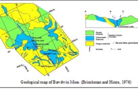
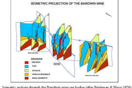
1. The lead deposits of Bawdwin Mine in the northern Shan States, Burma in Records of Geological Survey of India, Volume LXX in 1934.
2. Notes on a geological traverse in the Yunzalin Valley in Records of Geological Survey of India, Volume LX in 1928.
3. Notes on rocks in the vicinity of Kyaukse, Burma in Records of Geological Survey of India, Volume 71 in 1937.
4. Geology of Thayetmyo District, Burma in Records of Geological Survey of India, Volume 71 in 1937.
References: E. L. G. Clegg. 1938., General Report for 1938, Records of Geological Survey of India, Volume 74.
