EPISODE:25
A W G BLEECK
Bleeck contributed the papers; “Rubies in the Kachin Hills, Upper Burma”, “Jadeite in the Kachin Hills”, and “On some occurrences of wolframite lodes and deposits in the Tavoy district of Lower Burma” to Myanmar geology from 1907 to 1913. Due to limited space, I would like to extract some significant information from his comprehensive report on Jadeite in the Kachin Hills as follows: –
Jadeite in the Kachin Hills, Upper Burma
To judge by the long list of publications, our knowledge of Burmese jadeite should practically be complete, and yet there are numerous problems relating to the mode of occurrence and the genesis of jadeite which have not been solved satisfactorily. Most of the previous authors have based their views on the statements made by Dr F Noetling, the only other geologist who has visited the jade mines at Tawmaw. Dr Noetling’s survey of the jade-mines district, however, was incomplete, as he is careful in pointing out himself, owing to the fact that the unsettled state of the country and the impenetrable jungle impeded him in his work. I had to contend with the same difficulties, and although the jade mines themselves offer every opportunity for detailed petrographical investigation, the geology of the surrounding country could not be satisfactorily surveyed. A careful combination, however, of all the observations helps one to give a fairly good idea of the geological features of the district. The places visited on tour were Manwe, south of Kamaing on the Indaw chaung; Naniazeik, due west of Kamaing; Kansi, Lonkin, Mamon, and Houngpa, all on the Uru chaung; Tawmaw and Hweka, the former north and the latter south of Mamon.
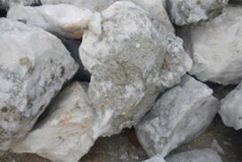
Jadeite is found at three places in the Kachin Hills: at Tawmaw, at Hweka, and at Mamon. The quarries and mines at Tawmaw are undoubtedly the most interesting. Tawmaw is situated on a plateau approximately 3,000 feet high. This plateau is about 10 miles long, stretching from north to south; its breadth, however, does not exceed one mile. The jadeite, associated with other minerals, occurs in a dyke of igneous origin. This dyke is intrusive into serpentine, which is the predominant rock on the plateau. The mines and quarries cover an area of ground approximately 500 yards long and 200 broad (Fig. 1.). Twelve shafts have been sunk on the jadeite dyke and are being worked. These numerous shafts and inclines represent different claims, which are let out to Chinese traders by the owner of the jade mines, a Kachin chief. Underground, the workings are connected up. Some, of course, are considerably deeper than others. Mining methods have not changed since Dr Noetling visited Tawmaw in 1892. The fire process for cracking the rock is still in vogue, exactly as previous authors have described it.
These mines are only worked for about three months in the year, from the beginning of March till the end of May; during the rain, malaria fever stops all work. In January, the Kachins begin to bail the mines, which fill up with water completely during the time they are not working. This laborious task takes nearly two months to complete. Day and night, a few scores of Kachins are at work bringing up the water in kerosine oil tins. After the bailing is completed, the mines are in a dangerous condition, and nearly all the complicated timbering has to be renewed. On the occasion of my first visit to Tawmaw, all the shafts were underwater, and I had to content myself with specimens picked up from the dumps. A month later, however, I revisited the place, and with the mines being dry by this time, I was able to study the jadeite in situ.
At Hweka, jadeite occurs in the shape of boulders in a conglomerate. Jadeite boulders are not very plentiful, but sometimes very large and, to judge by the crowd of Chinese buyers assembled at Hweka at the time of my visit, quarrying must be very remunerative. The quarries are situated on the steep slopes of a fairly high hill north of Hweka, and as there is no deep mining and consequently no accumulation of water in the workings, the season for the jade miner starts much earlier at Hweka than at Tawmaw.
The third jadeite-producing place in the Kachin Hills is Mamon. The mineral is found in the shape of boulders in the alluvial deposits of the Uru Chaung as well as in the bed of the river itself. Many years ago, jadeite boulders were found all along the upper reaches of the Uru as far as Sanka. All these workings, however, have been abandoned with the exception of those in Mamon’s immediate neighbourhood.
The geological features of the country west and north of the Indaw Chaung do not appear very complicated. The high ranges of mountains between Manwe and Naniazeik are almost entirely composed of granite. In several places, I traced irregular masses of crystalline limestone surrounded on all sides by this granite. The marble is generally of a pure white colour. In many places, it contains crystals of graphite, chondrodite, forsterite, phlogopite, etc. These minerals were developed by contact metamorphism of limestone by intrusive granite. It is significant that in many places, the Kachins have washed for corundum in the numerous little streams that come from these mountains. Furthermore, ruby mines were formerly worked near Naniazeik. Corundum is a specific contact mineral in crystalline limestone, and there can be no doubt that the abovementioned marble is the matrix that originally contained the corundum. From the fact that ruby mines are known to exist 11 miles north of Naniazeik, I gather that granite and crystalline limestone continue in this direction. Six miles to the northwest of Naniazeik, however, serpentine sets in and forms a range as far as Kansi and even beyond the Sanka chaung. These serpentine hills are all very much alike, with steep sides crowned by long and narrow plateaus.
South of Nanion, the landscape changes, the hills become much lower, and the slopes become gentler. These low ranges are entirely composed of a bluish-grey sandstone, which sometimes gives way to a coarse conglomerate. Identical rocks were found at Hweka, where the conglomerate is rich in jadeite boulders. Both sandstone and conglomerate are interstratified with very thin seams of coal. Some very badly preserved casts of dicotyledon leaves were collected. Mr J Schuster very kindly determined them to belong to a new species of Laurus, which he called Tetranthera Hwekonsis. These leaves are of some importance, as they prove the Tertiary age of the sandstones and conglomerates. In all probability, these strata are identical to the Miocene strata, which Dr Noetling mentions in this paper on jadeite in the Kachin Hills. Although the country lying between Hweka and Nanion could not be surveyed, it is very probable that these Tertiary strata continue as an uninterrupted series of rocks from Nanion as far as and even beyond Hweka to the south. The tertiary strata show considerable faulting.
West of Hweka, serpentine sets in again and continues on as far as Houngpa on the left bank of the Uru Chaung. On the western slopes of these serpentine hills overlooking the river, several almost horizontal terraces of brown iron ore occur, which are of a very interesting nature. This is not laterite, for which one is at first inclined to take it, but undoubtedly an iron-ore formed by precipitation from aqueous solution and must therefore be termed bog iron-ore or lake-ore.
North of Mamon on the left bank of the Uru, I came across a series of “crystalline schists.” These schists appear to form a small isolated occurrence bounded on one side by the Uru and on the other three sides by the Tertiary strata. They correspond to the crystalline schists occurring on the right bank of the river.
These latter are from the slopes of the range leading up to Tawmaw. Near the crest, the crystalline schists suddenly stop, and again, the serpentine forms the plateau. Crystalline schists of nearly identical outward appearance occur again on the western slopes of this mountain range.
The mineral resources of the jade-mines districts are, with the exception of jadeite, of no economic value whatsoever. Ruby mining at Naniazeik and Manwe has never been done at any profit, although systematic prospecting of the whole ruby and corundum tract may lead to favourable results. In the upper reaches of the Uru Creek, Kachins wash for gold. The work, however, can hardly be termed remunerative. The coal seams and chromite which occur in the serpentine near Tawmaw are not of sufficient quality for exploitation.
Six different groups of rocks will be treated in the following order: –
1. The granite and crystalline limestone west of the Indaw chaung between Naniazeik and Manwe.
2. The serpentine and basic eruptive rocks lie between the Sanka chaung and Naniazeik.
3. The Tertiary sandstones and conglomerates between Nanion and Hweka.
4. The serpentine and bog iron ore west of Hweka.
5. The “crystalline shists” on the left bank of the Uru creek.
6. The serpentine and “crystalline schists” on the right bank of the Uru creek. (Tawmaw series.)
Dr F. Noteling makes no mention whatever of the granite hills between Naniazeik and Manwe. The granite shows the usual varieties of coarse and fine grain. Dark crystalline concretions composed particularly of the more basic constituents of the rock are very abundant. Numerous veins of aplite and pegmatite traverse the granite. These bosses of granite enclose large masses of crystalline limestone.
The most important of the second group of rocks is the serpentine. Specimens collected on the march from Naniazeik to Kansi all closely resemble one another. A slight difference in colour is produced by weathering, the colours varying from dark green to brown green. Magnetite and chromite occur as dark concretions or tiny ill-defined veins throughout the rock. The microscope proves the rock to be normal serpentine. Chromite occurs as inclusions in the fresh olivine and is besides finely disseminated throughout the whole mass of serpentine. Magnetite is undoubtedly of secondary origin, as it only shows in the “serpentine minerals”. Northwest of Nanion, I came across some basic eruptive rocks closely resembling basalt. These rocks form low hills, which, for the most part, are unapproachable on account of dense jungle.
The third group of rocks under discussion are the Tertiary sedimentary strata. Both sandstones and conglomerates enclose short and thin coal seams and layers of coaly shale. The colour of sandstones and conglomerates is bluish-grey. The thickness of the sandstone beds must be very considerable, as judged by the profiles exposed on the cuttings of the new P W D road from Lonkin to Naniaseik. The sandstones gradually pass into conglomeratic sandstones and finally into a coarse conglomerate. The microscopic study of these rocks revealed the following component minerals: quartz, calcite, serpentine, plagioclase, glauconite, chlorite, and an amorphous dark organic substance. Quartz and glauconite are predominant. In no instance could any signs of metamorphism be discovered, the sandstones, etc., bearing a perfectly normal and unaltered aspect. As a “jadeite deposit” of considerable economic value, the conglomerate attracts our special interest. The numerous well-rounded large and small boulders of rock which make up the conglomerate consist chiefly of serpentine, quartz pyroxenite, saussurite-gabbro, and an occasional boulder of jadeite. The cementing matrix is a hardened clay of a dirty green colour. Boulders of saussurite-gabbro are fairly plentiful. The colour of the rock is dark brown or grey. One of the chief constituent minerals is a species of hornblende, which occurs in large corroded crystals.
The presence of boulders of jadeite, serpentine, etc., in the conglomerate proves conclusively that the geological age of these strata is younger than that of the surrounding masses of serpentine and that, therefore, the latter could not have been intrusive into the sandstones, etc.
The fourth group of rocks consists of serpentine and bog iron ores. They set in approximately two miles west of Hweka and again from long ridges or plateaus.
The group No 5 represents a series of crystalline schists. They vary in outward appearance as well as in mineral composition but nevertheless belong to a continuous series, the different types gradually passing into each other. The term “crystalline-schists,” which has been employed to designate this whole group of rocks, has no bearing whatsoever on their real nature. The origin of crystalline-schist cannot be explained other than by contact metamorphism produced in basic igneous rocks by intrusive granite.
A general survey of the jade mines gives one the impression that the jadeite occurs as a broad dyke in the serpentine. The strike of this dyke is N to S, and the dip averages 60°. In my opinion, an outcrop of white jadeite set off against the dark green of the serpentine must have led to the discovery of the jadeite at Tawmaw. The nature of the dyke is illustrated in Fig 2.
Jadeite is a mineral of high specific gravity. Minerals of high specific gravity suggest development under high compression due to orographic movements during the solidification of the rock. As a result of high pressure, a rock that, under normal conditions, would crystallize with the mineral paragenesis of albite-nephelite, etc., will develop the anomalous paragenesis of albite and jadeite. We may therefore assume that an intrusive dyke of dyke of mineral matter rich in soda can lead to the primary formation of an albite-jadeite rock when solidifying under anomalous conditions (i.e., piezo crystallization).
References: Bleeck, A W G, 1908: Jadeite in the Kachin Hills, Upper Burma, Record of GSI, Vol. XXXVI, Part 4.


