It is forecast that three low pressure areas may happen and two of them are likely to develop into depressions in early monsoon, according to the Department of Meteorology and Hydrology.
Storms happened in pre-monsoon generally hit the Rakhine coast and the delta.

“It is forecast that low pressure area will happen for three times in early monsoon. Of three, two has possibility of storm. In late monsoon, three times of low pressure area occurrence are forecast, and one has possibility of storm. Generally, storm in early monsoon happens on the Rakhine coast and the delta, based on data 30 years ago,” the department’s spokesperson U Hla Tun told the Global New Light of Myanmar (GNLM).

Storms in mid monsoon normally head to India but Myanmar needs to be alert, he said.
“In mid monsoon, normally storms do not approach Myanmar and they head to India. Monsoon is strong in mid monsoon so rain is high at the coastal areas. But storms in late monsoon should be cautious especially Myanmar’s coastal areas, because storms happen in early and late monsoon usually approach Myanmar’s coastal areas. It is possibility of the storm track,” said U Hla Tun.

In May and June, there is possibility of thunderstorm as a result of cumulonimbus clouds which are possible to happen, he said.
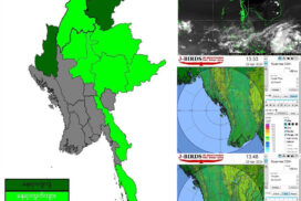
According to weather forecast on 10 May, cumulonimbus clouds are happening in Nay Pyi Taw, upper Sagaing Region, Tanintharyi Region, Kachin State, Shan State, Kayin State and Mon State, and forecast weather conditions include strong wind, torrential rain, lightning, thunderbolt and hailstorm, along with rain, along the areas where cumulonimbus clouds move, the department announced.
Thit Taw/ZS


