Severe Cyclonic Storm Condition
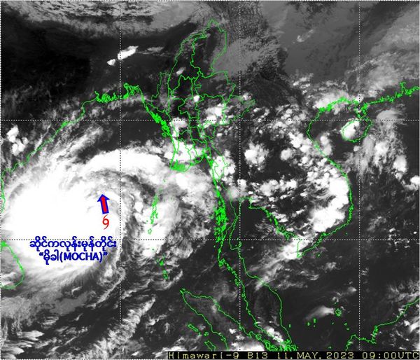
According to the observations at (20:30) hrs MST today, the Cyclonic Storm “MOCHA” over Southeast Bay of Bengal has moved Northwards and intensified into a Severe Cyclonic Storm “MOCHA”. It is centered at about (335) Nautical miles West-Southwest of CoCo Island, (435) Nautical miles West-Southwest of Hainggyigyun, (550) Nautical miles South- Southwest of Sittwe, (465) Nautical miles West-Northwest of Nicobar Islands (India), (285) Nautical miles West of Port Blair (India) and (590) Nautical miles South-Southwest of Cox’s Bazar (Bangladesh).
It is moving towards Bangladesh-Myanmar Coasts, the present stage of the Cyclonic Storm “MOCHA” is coded orange stage.
Position of Severe Cyclonic Storm “MOCHA”, center pressure and wind
Severe Cyclonic Storm “MOCHA” is located at Latitude (12.3) degree North and Longitude (87.9) degree East, centre pressure of Cyclonic Storm “MOCHA” is (992) hPa and maximum wind speed near the center is (60-70) miles per hour at (20:30) hrs MST today.
During next (4) days forecast
Severe Cyclonic Storm “MOCHA” is likely to move nearly Northerly during next (12) hours and intensify into a Very Severe Cyclonic Storm“MOCHA” over Central Bay of Bengal around (12.5.2023). Itrecurve gradually North-Northeastwards and forecast to cross Southeast Bangladesh and Northern Rakhine Coast between Cox’s Bazar (Bangladesh) and Kyaukphyu (Myanmar) near Sittwe (Myanmar) around (14.5.2023).
General caution
1. Due to the Cyclonic Storm “MOCHA”, rain or thundershowers will be fairly widespread to widespread in Nay Pyi Taw, Sagaing, Mandalay, Magway, Bago, Yangon, Ayeyawady, Taninthayi Regions and Kachin, Shan, Chin, Rakhine, Kayah, Kayin, Mon States with regionally heavyfalls in Lower Sagaing, Mandalay, Magway, Bago, Yangon, Ayeyawady Regions and Chin, Rakhine States and isolated heavy falls in Nay Pyi Taw, Upper Sagaing Region and Kachin, Shan, Kayin States from tonight to (15.5.2023).
2. From tonight to (14.5.2023), frequently squalls with rough to very rough seas will be experienced in Deltaic, off and along Rakhine Coasts. Surface wind speed in squalls may reach (80-100) m.p.h and Wave height will be about (13-16) feet in Deltaic, off and along Rakhine Coast and occassional squalls with rough seas will be experienced in Gulf of Mottama, off and along Mon-Tanintharyi Coasts. Surface wind speed in squalls may reach (40-45) m.p.h. Wave height will be about (9-12) feet in Gulf of Mottama, off and along Mon-Taninthayi Coasts.
3. Due to the Severe Cyclonic Storm “MOCHA”, maximum wind speed may reach (35-40) mph in Bago, Yangon, Ayeyarwaddy Regions and Rakhine State around (13.5.2023).
4. Due to the Severe Cyclonic Storm “MOCHA”, maximum wind speed may reach (100-105) mph in Rakhine State and (40-60) mph in Nay Pyi Taw, Lower Sagaing, Mandalay, Magway, Bago, Yangon, Ayeyawaddy Regions and Chin State during (13.5.2023) to (15.5.2023).
5. When crossing the Cyclonic Storm, storm surge height will be (10)ft to (14)ft in Estuary and Tributaries at Sittwe District, Maungdaw District Rakhine State and (7)ft to (10)ft in Estuary and Tributaries at Kyaukpyu District, Rakhine State.
Advisory
Under the influence of the Cyclonic Storm “MOCHA”, people should be awared of strong wind, heavy rain, flash flood and landslide in the hilly areas and near small rivers and also domestic flight, trawlers, vessels and ships off and along Myanmar Coasts. Therefore, people should watch the forecasts of The Department of Meteorology and Hydrology and make the necessary preparations.
Severe Cyclonic Storm Warning, No.9, 2023 11th May, 2023 21:30 MST Today
- May 12, 2023
- 459

